


 Français
 Deutsch
 Italiano
ACCOMMODATIONS NEAR THE SELLA PASS
Discover the best Hotels, B&Bs and Apartments in Mountain based on thousands of verified reviews.
Altitude2,240 m on the road (saddle 2,218 m)
WhereDolomites, South Tyrol – Trentino border
From Canazei12 km · bus 471 from Val Gardena via Plan de Gralba
GondolaSassolungo col · summer 2026: 30 May–11 Oct
SkiingSellaronda · Dolomiti Superski 89 € a day (high season 2026/27)
Seasonwinter 4 Dec 2026–4 Apr 2027 · road open except avalanche closures
Updated October 2026 · Sources: Val Gardena, ApT Val di Fassa, Visit Trentino, Dolomiti Superski, Province of Trento
Find a place to stay near the Sella Pass
Sella Pass (Passo Sella in Italian, Sellajoch in German, Jëuf de Sela in Ladin) links Val Gardena and Val di Fassa in the Dolomites. The road tops out at 2,240 metres, the height on the sign at the summit; the actual saddle point, as measured by the Val Gardena tourist board, is 2,218 metres. The pass is the border between the provinces of Bolzano (South Tyrol) and Trento: on one side you drop down to Selva di Val Gardena via Plan de Gralba, on the other to Canazei, 12 km away.
Few Dolomite passes sit this close to two mountain groups. To the west rise Sassolungo (3,181 m) and Sassopiatto, to the east the Sella Towers. In between you find the Città dei Sassi, a field of huge boulders that fell from Sassolungo, a historic stand-up gondola to the Sassolungo col, and some of the busiest trails in the Dolomites, from the Sassolungo circuit to the Friedrich August path.
The pass works all year. In summer you arrive by car, motorbike, bike or public bus and start walking straight from the car park. In winter it is one of the four passes of the Sellaronda ski circuit around the Sella group. The nearest airport is Bolzano, about 40 km from Val Gardena; most international visitors fly into Venice, Verona, Innsbruck or Munich.
In this guide
What to see at Sella Pass
Almost everything is a short walk from the car park, or one lift ride away.
The pass and the view
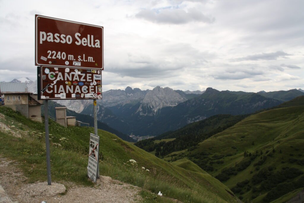
From the highest point of the road you have Sassolungo right in front of you, the Sella Towers opposite and, to the south, Val di Fassa dropping towards Canazei. On clear days you can see the Marmolada in the distance. It is the viewpoint everyone comes for, and you barely need to leave the car, but in July and August the car park fills up by mid-morning. Arrive early.
Sassolungo and Sassopiatto
Sassolungo (Langkofel in German, Saslonch in Ladin) is Val Gardena’s signature mountain: 3,181 metres, with vertical walls that start almost at the road. Next to it, the lower Sassopiatto is easy to spot from afar thanks to its tilted profile. Together they form one group that you can walk all the way round (see below). The summit of Sassolungo is for climbers only, not hikers.
The Sella Towers
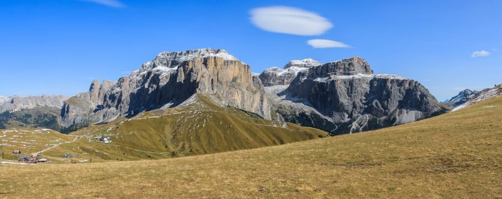
East of the pass stand the Sella Towers, the first spires of the great massif that gives its name to the pass and to the Sellaronda. They are a classic climbing area. For walkers, the best view is from the path to the Città dei Sassi.
Città dei Sassi (Stone City)
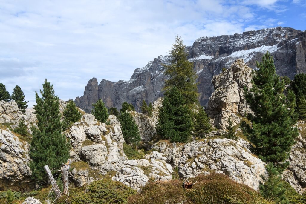
The Città dei Sassi is a maze of house-sized boulders that fell from Sassolungo, scattered among meadows and small woods. Boulderers love it, and so do families, because it is an easy walk. A path crosses it and links the pass with the Emilio Comici hut on the Val Gardena side.
For an easy walk with information boards, follow the Naturonda trail: 7.1 km, about an hour, almost all downhill towards Val Gardena, with panels on plants, wildlife and geology. It starts at the bus stop on the pass; to get back, take the bus or walk up trail 526.
The chapel at the pass
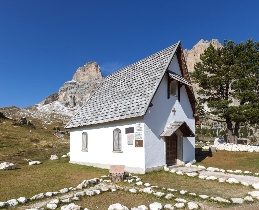
Near the road there is a small chapel with Sassolungo behind it. It is one of the most photographed spots on the pass.
Sassolungo col (Forcella del Sassolungo)
The Forcella del Sassolungo is the notch between Sassolungo and Sassopiatto, at about 2,700 metres. A historic gondola with tiny stand-up cabins runs up from the pass; at the top is the Toni Demetz hut, built in the 1950s. Practical details are in the dedicated section below.
Col Rodella
Col Rodella (2,480 m) is the grassy ridge south of the pass, on the Val di Fassa side. You can get there by cable car from Campitello or on foot from the pass on trail 557. The view takes in the Sella, Sassolungo and the Marmolada. There is also a short via ferrata here, suitable for beginners.
The Val di Fassa side
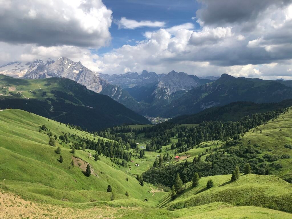
Heading down to Canazei, the road crosses open pastures with one of the widest views over Val di Fassa. Lower down it joins the Pordoi Pass road. For photos, stop only in proper lay-bys.
Hiking from Sella Pass
Sella Pass is one of the easiest trailheads in the Dolomites: you start above 2,200 metres and the paths leave from the car park. Here are the main walks, from easy to demanding.
Friedrich August path (no. 557)
Opened on 30 July 1911, the path is named after King Friedrich August III of Saxony, a regular visitor to these valleys. It heads south from the pass over the Sela Rodela and runs almost level along the southern side of Sassolungo and Sassopiatto, facing the Marmolada and the Catinaccio (Rosengarten).
The first stretch, past the Friedrich August hut to the Sandro Pertini hut, suits families with children, but with a baby carrier, not a pushchair. The path then continues to the Sassopiatto hut (2,297 m) and the Alpe di Siusi, with more demanding sections.
Sassolungo circuit
The full loop around Sassolungo and Sassopiatto is the local classic. The Val Gardena tourist board gives it as 17.3 km, about 5 h 25 min of walking and 842 metres of ascent and descent, starting from Monte Pana above Santa Cristina. From Sella Pass you join the loop halfway: on the south side trail 557 (Friedrich August), on the north side trail 526 below the walls, past the Comici hut and through the Città dei Sassi.
There are no technical sections on the classic route, but it is a full day with plenty of ups and downs. Start early and carry water and warm layers: above 2,000 metres the weather turns quickly, even in summer.
From the col back to the pass on foot
A popular option: ride the gondola up to the Forcella del Sassolungo and walk down. Trail 525 drops straight back to the pass; it is steep and loose, so wear proper hiking boots. Experienced hikers can instead descend the north side towards the Vicenza hut and Val Gardena: the path is very steep, partly secured with cables, and the Val Gardena mountain rescue team is often called out for walkers who underestimated it.
Walking up from Val Gardena
If you want to reach the pass without a car, these are the official Val Gardena figures: from Plan de Gralba 1 h 20 min, 400 metres of ascent, 5.2 km on trail 657; from Selva centre 2 h 30 min, 614 metres, 8 km. Take the Ciampinoi gondola from Selva and you are left with 4.3 km, about 1 h 30 min of walking and just 141 metres of climbing.
Via ferratas
Around the pass there are via ferratas for every level: the Col Rodella route for beginners; the Mèsules (Pössnecker) via ferrata on the Sella, long and demanding; and from the col, the Oskar Schuster route towards Sassopiatto and the normal route up Sassolungo, which is a proper climb. For the harder routes, hire a mountain guide.
The Sassolungo col gondola
The gondola leaves right from the pass and climbs to the Forcella del Sassolungo, next to the Toni Demetz hut. It is a historic lift: two-person cabins in which you stand, which is why locals jokingly call it “the coffin”. The ride is short, but arriving in the gully between the two peaks is one of the highlights of a day at the pass.
- Summer season 2026: 30 May to 11 October (Val Gardena tourist board).
- Opening hours: 8:15 am to 5 pm (Dolomiti Superski).
- Tickets: at the ticket office or online; the Dolomiti SuperSummer Card is valid (67 € per day in 2026).
- Single ride prices: check at the ticket office or on the lift company’s website, as they change every season.
On busy summer days there can be queues, because the cabins carry so few people. Go early in the morning. In strong wind the lift may stop.
Sella Pass in winter and the Sellaronda
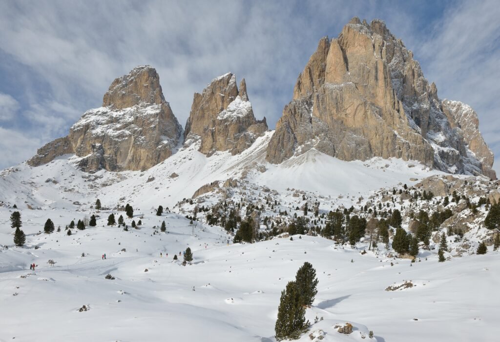
In winter the pass sits at the heart of the Col Rodella ski area and the Sellaronda. The pistes link Val Gardena (Plan de Gralba and Ciampinoi) with the Val di Fassa side, where the Belvedere–Col Rodella area has 31 km of runs and 23 lifts. The Sellaronda is 44 km long, 23 km of it on piste: going anticlockwise (green signs) from Selva, Sella Pass comes first; clockwise (orange), it is the last pass before you return to Val Gardena.
The 2026/27 season runs from 4 December 2026 to 4 April 2027, snow permitting. You need the Dolomiti Superski pass: in high season an adult day pass costs 89 € (453 € for six days). Full details of the circuit are on our Sellaronda page.
The road normally stays open in winter, but it can close because of avalanche risk, sometimes for several days, on both sides. Drive with winter tyres or carry chains, and check road conditions before you set off. At the pass you can also go snowshoeing or walk on groomed winter paths.
Sella Pass by bike and motorbike
Sella is one of the four passes on the road loop around the Sella group: about 53 km and 1,700 metres of climbing. In 2027 the Sellaronda Bike Day, when the roads over the four passes are closed to cars and motorbikes from 9 am to 4 pm, falls on Saturday 5 June and Saturday 11 September. The Giro d’Italia has climbed Sella Pass since 1940; in 2024 it was the first climb of the stage that started in Selva.
On a mountain bike you can ride up from Plan in Val Gardena on routes 223 or 308: 16.9 km, 796 metres of climbing, about 2 h 35 min, intermediate. The pass is also on the Sellaronda MTB Tour, which uses lifts for the climbs.
For motorcyclists, Sella is a fixture of any Dolomite passes ride. Avoid the middle of the day in July and August: traffic is heavy and roadside parking is banned.
Traffic and rules on the Dolomite passes (2026–2027)
As of 14 October 2026 there is no toll and no restricted traffic zone on Sella Pass, and no official measure has been announced for 2027. The pass has been a test case before: in summer 2017 the road was closed to cars on Wednesdays in July and August (the Dolomites Vives project), and in summer 2018 access was capped at about 350 vehicles a day with a one-hour permit. The scheme has not been repeated since 2019.
The news concerns neighbouring Gardena Pass: since 22 September 2026 the Province of Bolzano has been running a digital test there, and a seasonal restricted zone is being studied for 2027. No final rules exist yet. If it goes ahead, more traffic may shift to Sella and Pordoi. Check the official South Tyrol and Trentino road information before you travel.
The rules already in force are simple: very few parking spaces at the pass, paid parking, no stopping along the road.
When to go to Sella Pass
- June: the col gondola runs from 30 May and summer buses start in June; there may still be snow on high trails.
- July and August: everything is open and huts and buses run at full capacity, but so does the traffic. Arrive before 9 am or take the bus.
- September and early October: the best time to hike, with fewer people and clear light. The gondola closes on 11 October (2026 season).
- December to April: skiing and the Sellaronda, 4 December 2026 to 4 April 2027.
- November and May: off-season, lifts closed and many huts shut.
Day trips from Sella Pass
- Pordoi Pass: the neighbouring pass, with the Sass Pordoi cable car and the route to Piz Boè.
- Gardena Pass: towards Alta Badia, between the Sella and the Cir group.
- Val Gardena: Ortisei, Santa Cristina, Seceda and the Alpe di Siusi.
- Val di Fassa: Canazei, Campitello, the Marmolada and Lake Fedaia.
Where to stay near Sella Pass
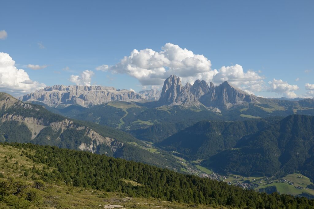
On the pass itself there are only a few hotels and huts: ideal for setting off at dawn, but beds are limited and book up early. Most visitors stay down in one of the two valleys the pass connects.
- Selva di Val Gardena and Plan de Gralba: the best choice for skiers and the Sellaronda; in summer bus 471 runs up to the pass from Plan de Gralba roughly every 15 minutes at peak times.
- Canazei and Campitello di Fassa: a good base on the Trentino side, with Col Rodella and the Belvedere right above town.
- Without a car: pick a Val Gardena village near the 350/352 bus stops, or Canazei for bus B129.
- Families: apartments in Selva or Campitello, handy for the Città dei Sassi and the Friedrich August path.
How to get to Sella Pass
By car
From the north and Bolzano: A22 motorway, exit Chiusa/Val Gardena, then the SS242 through Ortisei, Santa Cristina and Selva; shortly after Plan de Gralba the road climbs to the pass. From the south: A22, exit Egna-Ora or Bolzano Nord, to Val di Fassa and Canazei; from there follow the SS48 towards Pordoi and, at the Pian Schiavaneis junction, take the Sella road. From Canazei it is 12 km, about 15 minutes in normal traffic.
By train
For Val Gardena the nearest stations are Ponte Gardena (18 km) and Chiusa (23 km) on the Brenner line, then bus 350. For Val di Fassa, get off at Bolzano or Ora and continue by bus. No train reaches the pass.
By bus
In summer line 471 connects Val Gardena with Sella Pass and continues towards Canazei and Pordoi; at peak times it runs roughly every 15 minutes. Early in the morning some runs are direct; during the day you usually change at Plan de Gralba from lines 350 or 352. In 2026 it ran from 7 June to 11 October. With the Val Gardena Guest Pass the bus is free, and children up to 6 travel free. From Val di Fassa, line B129 Canazei – Sella Pass ran from 27 June to 9 September 2026. Bikes are not allowed on the pass buses; dogs must be leashed and muzzled.
By plane
Official distances from Val Gardena: Bolzano 40 km, Innsbruck 120 km, Verona 190 km, Treviso 230 km, Venice and Bergamo 270 km, Munich 300 km, Zurich 420 km. From Val di Fassa: Treviso 160 km, Venice 175 km, Verona 180 km. Airport transfers run to the valleys in winter; for the pass itself a hire car gives you the most freedom.
Parking
The car park at the pass is paid and very small. Parking along the road is not allowed. In high season it fills early: arrive before 9 am, or leave the car in the valley and take the bus. Rates are posted on site.
Frequently asked questions about Sella Pass
How high is Sella Pass?
The road reaches 2,240 metres, the height on the summit sign. The actual saddle is at 2,218 metres, which is why you see different figures.
Where is Sella Pass?
In the Dolomites, on the border between South Tyrol (Val Gardena, municipality of Selva) and Trentino (Val di Fassa, Canazei), between Sassolungo and the Sella group.
How far is Sella Pass from Canazei?
12 km, about 15 minutes by car. In summer there is also bus B129.
Do you have to pay to park at Sella Pass?
Yes, the car park is paid and small. Parking along the road is banned.
How do you get to Sella Pass without a car?
In summer, take bus 471 from Val Gardena (change at Plan de Gralba) or B129 from Canazei.
What is the Città dei Sassi?
A field of huge boulders that fell from Sassolungo, right by the pass. An easy path crosses it; the Naturonda trail is 7.1 km and takes about an hour.
Can you do the Friedrich August path with a pushchair?
No. As far as the Sandro Pertini hut it is family-friendly, but with a baby carrier.
When does the Sassolungo col gondola run?
In 2026 from 30 May to 11 October, 8:15 am to 5 pm. The 2027 dates have not been published yet.
Is Sella Pass open in winter?
Normally yes, but it can close temporarily because of snow and avalanche risk. Winter tyres or chains are needed.
Are there traffic restrictions on Sella Pass?
Not in 2026: no toll and no restricted zone. For 2027 a restricted zone is being studied only for Gardena Pass; the pass roads do close on 5 June and 11 September 2027 for the Sellaronda Bike Day.
Photos: Passo Sella
Photos from Wikimedia Commons: Sönke Kraft aka Arnulf zu Linden (CC BY-SA 3.0), Sönke Kraft aka Arnulf zu Linden (CC BY-SA 3.0), H. Zell (CC BY-SA 3.0), H. Zell (CC BY-SA 3.0), H. Zell (CC BY-SA 3.0), Einaz80 (CC BY-SA 4.0), This Photo was taken by Wolfgang Moroder.
Feel free to use my photos, but ple (CC BY-SA 3.0), This Photo was taken by Wolfgang Moroder.
Feel free to use my photos, but ple (CC BY-SA 3.0).


