


 Français
 Deutsch
 Italiano
ACCOMMODATIONS IN VALMALENCO
Discover the best Hotels, B&Bs and Apartments in Mountain based on thousands of verified reviews.
AltitudeChiesa 960 m · Lanzada 983 m · Caspoggio 1,098 m
WhereProvince of Sondrio, Lombardy
From Milanabout 100 km to Sondrio · just over 2 h to Chiesa
SkiingAlpe Palù · about 50 km of slopes · up to 2,370 m
AccessSnow Eagle cable car · 2,080 m in 4 minutes
SummerAlta Via della Valmalenco · about 110 km, 8 stages
Updated October 2026 · Sources: Sondrio e Valmalenco tourist board, Wikipedia, ISPRA
Find a place to stay in Valmalenco
Valmalenco is the side valley of the Valtellina that climbs north from Sondrio to the Bernina group, in the province of Sondrio, in Lombardy. It is shared by five municipalities: Chiesa in Valmalenco, Lanzada, Caspoggio, Torre di Santa Maria and Spriana. The main village is Chiesa in Valmalenco, at 960 metres, with about 2,200 inhabitants, around 11 km north of Sondrio. The valley covers a huge range of height: from just over 300 metres at the valley floor to the Bernina peaks, which pass 4,000.
From Milan it is about 100 km to Sondrio and a little over two hours by car to Chiesa, on the SS 36 and SS 38 along Lake Como. Without a car you take the train to Sondrio and then the local bus up the valley. That makes Valmalenco one of the easiest mountain destinations from Milan, even for a weekend.
In winter you come to ski at Alpe Palù, the area above Chiesa, reached by the big Snow Eagle cable car. In summer you come for the lakes, the mountain huts and the Alta Via della Valmalenco, and for Monte Disgrazia, the peak that dominates the valley. The local rock is serpentine, and you see it in the houses, the roof slabs and the quarries.
What to see in Valmalenco
You can drive around the valley in a day, but the best places are higher up. Altitudes below come from Wikipedia and from the tourist board and Ecomuseum websites.
Chiesa in Valmalenco
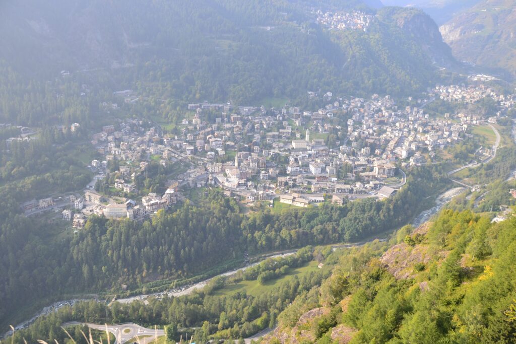
Chiesa is the biggest village and the service centre: shops, buses, the cable car to Alpe Palù. It includes the hamlets of Chiareggio, Primolo and San Giuseppe. In the square stands a monument to the Alpino d’Italia, from 1984, made with local serpentine. On 4 June 1988 stage 13 of the Giro d’Italia finished here, won by the Swiss rider Tony Rominger.
To understand the valley, the Museo storico etnografico naturalistico e di mineralogia in Chiesa holds archaeological finds (rock engravings, Roman objects), farm tools, minerals and documents on mountaineering. Opening is by request: call ahead.
Alpe Palù and Lago Palù
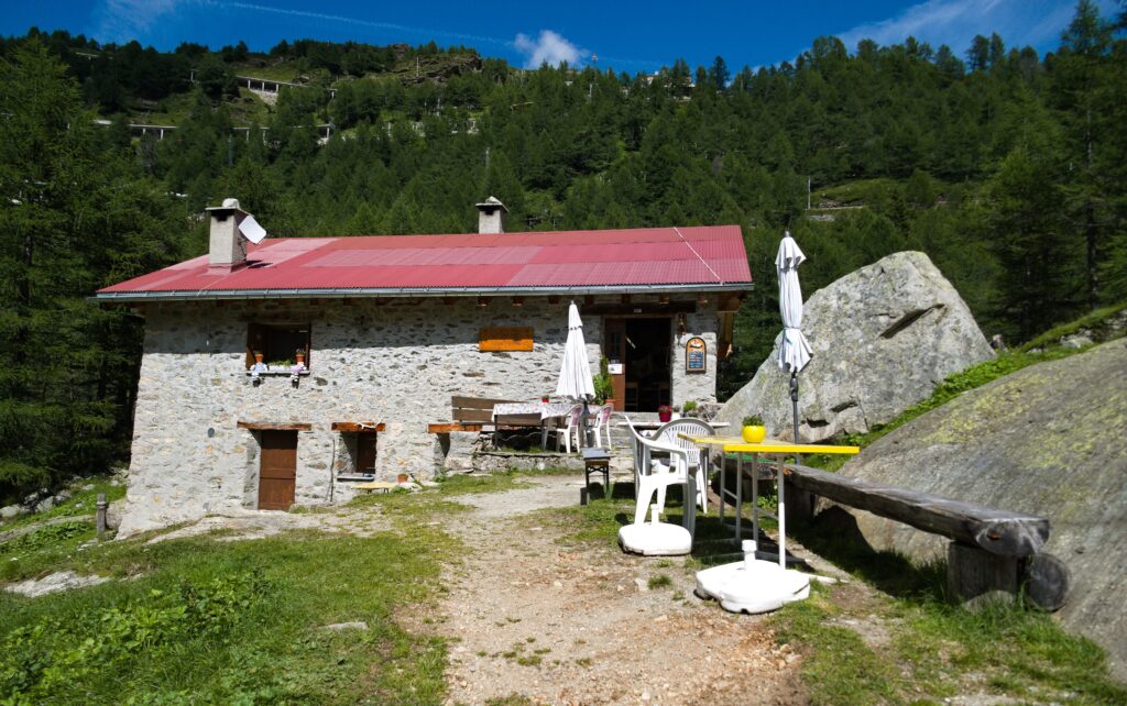
Alpe Palù is the tourist heart of the valley. You get there by the Snow Eagle cable car from Chiesa (top station at 2,080 metres, cabins for 160 people, about 1,000 metres of height gain in 4 minutes), or by car on the 5 km road from Chiesa to San Giuseppe and then the four-seater chairlift. In winter it is the ski area; in summer it is a mountain pasture with trails and Lago Palù, with Disgrazia in the background. The lake loop starts from the San Giuseppe chairlift car park: about 8.5 km and about 3 hours, according to local guides.
Lanzada, Campo Moro and the Bagnada mine
Lanzada (983 m) is the second municipality of the upper valley (117 km²) and takes in the slopes towards the Bernina. Here you find the Bagnada mine and the Ecomuseo della Valmalenco, about mining: more than 260 of the roughly 450 mineral species of the province have been found in the valley. The road climbs to Franscia and Lago di Campo Moro, the starting point for the huts and trails of the Bernina. Note: a landslide in November 2025 closed the municipal road between Lanzada, Franscia and Campo Moro. In summer 2026 a free shuttle, from 20 June to 13 September, took people to Campo Moro from the Tornadri car parks. For 2027 there are no firm reopening dates: check with the tourist board first.
Caspoggio, Torre di Santa Maria and Spriana
Caspoggio (1,098 m, about 1,300 inhabitants) is a quiet village and a good start for hikes. Torre di Santa Maria, at the mouth of the valley, at 770 metres, is the start and end of the Alta Via della Valmalenco. Spriana is the fifth municipality of the valley.
Monte Disgrazia and the Bernina group
Monte Disgrazia (3,678 m) separates Valmalenco from Val Masino. The first ascent was on 24 August 1862 by an English party including Leslie Stephen. The normal route is the Pioda ridge: this is mountaineering, not hiking, so you need a guide or glacier experience. To the east the Bernina group passes 4,000 metres: Punta Perrucchetti (4,020 m) is the highest peak in Lombardy, a few hundred metres from Pizzo Bernina (4,049 m), which is in Switzerland.
Serpentine and soapstone
From the 6th to the 11th century soapstone (pietra ollare) was quarried in the valley for cooking pots (lavecc), and serpentine is still worked today for roof slabs and crafts. It is part of the local identity: you see it in houses, walls and monuments. There are no public quarry visits that we could confirm: ask the tourist board or the Ecomuseo if you want to see the work.
Skiing in Valmalenco

The ski area is Alpe Palù, run by Funivie al Bernina. It is not a huge area, but it has real vertical (from 1,500 to 2,370 metres) and slopes that the tourist board divides into easy, intermediate and difficult. These are last season’s figures: the 2026/27 numbers are not yet published, so check before you go.
Slopes and lifts
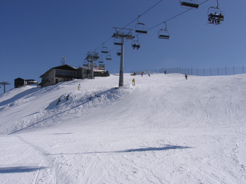
According to the Sondrio Valmalenco tourist board the area has about 50 km of slopes and 9 lifts: one cable car, six chairlifts, one conveyor and one inclined lift. The highest point is Bocchel del Torno at 2,370 metres. The longest run drops about 900 metres. About 40 km of slopes have snowmaking. The board quotes average gradients up to 55% on some slopes, so there are runs for strong skiers and easier stretches for beginners. The snowpark is for snowboarders and freestylers.
For 2026/27 the official opening date is not yet confirmed. The tourist board promotes the lift opening for the Immacolata bridge (8 December), and the season normally runs to late April. The operator has not yet published 2026/27 lift pass prices: check the official price list and the Valmalenco Card before buying.
Cross-country, snowshoes and ski touring
Cross-country has six tracks for about 38 km. The best known are Lago Palù (7 km), Senevedo (8 km) and Chiareggio–Pian del Lupo, the longest at 12 km. The 1.2 km Lanzada–Pradasc loop is lit in the evening. Snowshoeing is on Lago Palù and on routes towards the alpine pastures of Entova, Musella, Prabello and towards Lago di Chiesa. Ski touring and freeride are possible throughout the group, but need training and equipment: the tourist board lists classic routes without giving distances.
Summer in Valmalenco
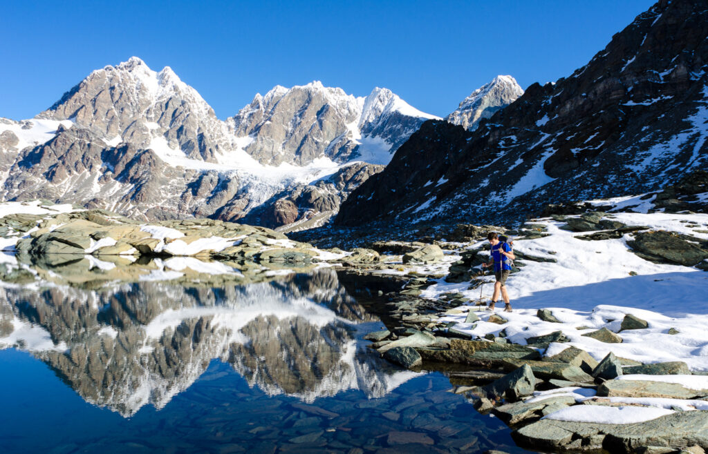
In summer Valmalenco is a valley of mountain huts. Some routes are short and easy; others are multi-day high-altitude tours.
Alta Via della Valmalenco
This is the classic trek: a loop of about 110 km that starts and ends in Torre di Santa Maria (770 m) and crosses the Scalino, Bernina and Disgrazia groups in 8 stages. Total walking time is about 47 hours, the high point is Bocchetta di Caspoggio (2,983 m) and nearly all of it is above 2,000 metres. It passes the huts Cometti, Bosio-Galli, Gerli-Porro, Camerini, Longoni, Palù, Carate Brianza, Marinelli Bombardieri, Bignami and Cristina. Book the huts, especially in August, and go between July and September depending on snow.
Main huts
A few altitudes to help you choose: Gerli-Porro (1,956 m), Longoni (2,450 m), Carate Brianza (2,636 m), Marinelli Bombardieri (2,813 m). Marinelli is a base for the Bernina: a demanding climb, not a stroll. Times and ascents of individual trails change with the season: use the tourist board’s route sheets.
Sentiero Roma
The Sentiero Roma is a route of about 54 km with about 2,900 metres of ascent, graded difficult. Most of it is in Val Masino and it ends at the foot of Disgrazia, so it only touches Valmalenco at the edge. Do it with experience.
Lakes and easy walks
Lago Palù is the easiest walk, starting from the San Giuseppe chairlift car park (see above). Other lakes in the valley, such as Campo Moro, Entova, Arcoglio, Campagneda and Sassersa, are hikes of varying length. In general the high lakes take a few hours on foot: they are not flip-flop outings.
Glaciers
The Disgrazia, Bernina and Scalino glaciers can be seen from trails and the highest huts. Walk on the ice only with a guide and equipment.
What to eat in Valmalenco
The tourist board and tourism websites mention cured meats and mountain cheeses, mushroom tagliatelle, beef tagliata with polenta taragna and apple strudel: the hut and alpine pasture food of the Valtellina. For restaurant names, ask the tourist office or the hut keepers.
Day trips from Valmalenco
- Sondrio: the provincial capital, 11 km south, with the Collegiata dei Santi Gervasio e Protasio, the Museo valtellinese di storia e arte and Castel Masegra.
- Madesimo: the neighbouring valley in Valchiavenna, with another ski area.
- Bormio: thermal baths and skiing in the Upper Valtellina.
- Aprica: a lower, family-friendly area between the Valtellina and Val Camonica.
- Livigno: skiing and duty-free zone, further away.
- Saint Moritz: from the Valtellina you reach the Engadine through Switzerland; it is not an easy day trip in winter.
Where to stay in Valmalenco
Accommodation is mostly family-run hotels, apartments and farm stays. Which area suits you depends on what you do.
- Chiesa in Valmalenco: the best base for skiing, because the cable car starts in the village; also handy without a car and for services.
- Caspoggio and Lanzada: quieter, good for summer hiking and often cheaper.
- Primolo, San Giuseppe and Chiareggio: higher hamlets, for silence and for starting on foot or on cross-country skis.
- Sondrio: if the valley is full, the town has more choice and the train; the bus goes up the valley.
Book early for the Immacolata bridge, Christmas and August.
How to get to Valmalenco
By car
From Milan follow the SS 36 towards Lecco and Lake Como, then the SS 38 through the Valtellina to Sondrio and go up the valley: about 2 hours 20 in normal traffic. From Chiesa the road continues to San Giuseppe and Chiareggio. In winter carry winter tyres or chains.
By train
The station is Sondrio, on the Milan–Tirano line, then continue by bus. Timetables at Trenord.
By bus
From Sondrio, STPS local buses go up to Chiesa in Valmalenco. Timetables change by season and are not very frequent: check on STPS.
By plane
The reference airports are Milan (Malpensa and Linate) and Bergamo. Then continue by car or by train and bus. From Lugano and Switzerland, plan a longer route: check it in advance.
Parking
In Chiesa there are car parks near the cable car; in high season arrive early. Information from the Sondrio e Valmalenco tourist board.
Frequently asked questions about Valmalenco
Where is Valmalenco?
In the province of Sondrio, in Lombardy: it is the valley climbing from Sondrio towards the Bernina group, north of the Valtellina.
Which municipalities are in Valmalenco?
Five: Chiesa in Valmalenco, Lanzada, Caspoggio, Torre di Santa Maria and Spriana.
What is the altitude of Chiesa in Valmalenco?
960 metres. Lanzada is at 983 and Caspoggio at 1,098.
How far is Valmalenco from Milan?
About 100 km to Sondrio and a little over two hours by car to Chiesa.
How long are the slopes at Alpe Palù?
About 50 km according to the tourist board, up to 2,370 metres. Some sources say 60 km: the 2026/27 figures need confirming.
How do you get up to Alpe Palù?
By the Snow Eagle cable car from Chiesa, or by car to San Giuseppe and then the chairlift.
What is there to do in Valmalenco in summer?
Hut and lake hikes, the Lago Palù loop, the Alta Via della Valmalenco and visits to the museums and the Ecomuseo.
How long is the Alta Via della Valmalenco?
About 110 km in 8 stages, a loop from Torre di Santa Maria.
How high is Monte Disgrazia?
3,678 metres. The normal route is the Pioda ridge and is a mountaineering ascent.
Can you drive to Campo Moro?
After the November 2025 landslide the road was closed and in 2026 there was a free shuttle. For 2027 check the status with the tourist board.
Photos from Wikimedia Commons: Luca Casartelli (CC BY-SA 3.0), Gaggi Luca 76 (CC BY 3.0), Tiia Monto (CC BY-SA 3.0), Gaggi Luca 76 (CC BY 3.0), Zbigniew Rutkowski (CC BY-SA 3.0).


